Standby Human Resources

SBTF volunteers have consistently demonstrated they are a reliable, hard working and creative bunch. On little notice, they are willing to put in hours of their free time, all the while holding a job / writing a PhD / entertaining three toddlers. Their encouragement and interaction with similar volunteers comes through a computer screen - emails, skype emoticons and the occasional call. Most SBTF skype chat rooms are full of positive comments (we once did a wordle of a deployment skypechat, and “(rock)” featured pretty prominently).

All that said, sometimes nerves can fray and conflicts flare up. As a growing network, we increasingly need to put systems in place to ensure we can maintain harmonious relations, especially at times of stress. This is why we have put together a formal SBTF Complaints Protocol, which you can view here.

In order to manage complaints, we have also set up a Human Resources Team. The HR team is responsible for providing support on issues relating to human resources to the entire SBTF, in particular:

  • Intervene and mediate between volunteers when alerted to a conflict between them
  • Receive and handle formal complaints from volunteers following the SBTF Complaints Protocol
  • Maintain confidentiality of all cases handled within the HR Team
  • Survey volunteers during deployments to assess burn-out levels
  • If serious concerns about the psychological health of a volunteer arise that require immediate intervention, contact the SBTF Counsellor for support

Two experienced SBTF volunteers (Leesa Astredo and Christina Kraich-Rogers) will be the Coordinators of this team and will be responsible for:

  • When no deployments are active, be the focal point for all activities above
  • For any deployment, create a schedule for the HR team volunteers to assure coverage
  • Instruct volunteers on how to manage complaints, mediations and referrals
  • Keep a confidential document with all HR cases handled / action taken

A standbytaskforce.com needs standby human resources. Together with the psychological support recently added to the SBTF, we hope this new HR Team will help us all keep working in happy, productive and welcoming environment.

Posted in Uncategorized | Tagged , , | Leave a comment

A Review of SBTF Deployments

It’s a new year and the Core SBTF Team is busy developing its roadmap for. We have recently expanded the Core Team with experienced volunteers who have done phenomenal work on previous SBTF deployments. We are also updating our Ning platform, blog, Facebook page, etc. For example, we recently added a Coordinators Page and Deployments Page on our blog.

Since launching in October the SBTF has engaged in no fewer than 18 (!) deployments. Of these, a total of 9 were “Official Deployments” while 9 were “Side Deployments.” Official Deployments are those for which the activating organization meets all our “Activation Criteria.” For example,  the activating organization must clearly demonstrate & explain:

  • A direct need for the live map
  • How they will use the data collected
  • The capacity to respond on the ground

We had actually not anticipated the idea of “Side Deployments” when we first set up the SBTF. But we soon found ourselves asked to support a number of live mapping initiatives that did not directly meet our criteria. But we had the time and indeed considerable interest from SBTF volunteers to get engaged regardless, particularly if we were not in the middle of an Official Deployment. Side Deployments have given new volunteers an ideal opportunity to develop their skills and master the various workflows of the SBTF. So they have become really key to our work.

Of the 18 deployments, 2 were simulations with UN partners; 2 were elections related; 6 were in response to “natural” disasters such as floods and earthquakes; 6 were conflict related; 1 was related to public health and 1 to activism. October was the first time we had 2 deployments in one month; while December saw no fewer than 4 individual deployments. The longest deployment was the Libya Crisis Map which took about 4 weeks. The shortest deployments ranged from 2-3 days in duration.

In terms of the groups activating the SBTF, the UN (OCHA, UNHCR, WHO) activated the Task Force 5 times and twice for simulation exercises; Civil society group 6 times; Amnesty International (USA) once; ABC Australia once; Al-Jazeera once; and local disaster management agencies twice. In terms of specific SBTF Teams activated for these deployments, the Media Monitoring Team, Geo-Location Team and Reports Team are most often activated. This makes sense since these teams represent core information management processes. The newest member to the SBTF is the Satellite Imagery Team, which was activated twice in the Fall of. The Translation Team and SMS Team have yet to see action in a live deployment.

While reviewing this list of SBTF deployments, I was also struck by another realization. Of the 18 deployments, a total of 14 involved the use of the Ushahidi platform. The other 4 leveraged other platforms like OpenStreetMap (OSM) and Tomnod. For each of the 14 deployments that used Ushahidi, the SBTF was not involved in the decision to use the Ushahidi platform. Each time SBTF volunteers used an Ushahidi platform following an activation, it was the activating organization that either had already set up an Ushahidi platform or directly requested the use of an Ushahidi platform. Indeed, of those 14 SBTF deployments, no fewer than 11 already had an Ushahidi platform set up even before the SBTF was contacted.

The 4 SBTF activations that did not use Ushahidi all took place within the past few months. This is perhaps an indication that our efforts to diversify are finally starting to pay off. When we launched the network in October we immediately reached out to multiple partners including OSM & Sahana and repeatedly invited them to train SBTF volunteers so they would have additional “surge capacity” available to them. While Sahana has yet to RSVP, our colleagues at OSM did provide 1 introductory training about a year after our first invitation.

Since then, SBTF volunteers have also been trained in using the Tomnod platform for micro-tasking satellite imagery analysis. In addition, two companies recently approached us offering their information management tools for free along with pro bono training. We look forward to evaluating these tools and integrating them into our workflows if appropriate. Incidentally, other tools that we couldn’t live without for the work we do include our dedicated Ning platform, Google Groups & Apps and Skype.

Our modular team-based approach and corresponding workflows are not tied to a particular piece of software but rather reflect core aspects of knowledge management and information processing. Indeed, each of our Teams represent key information management processes. This explains why the workflows for the Media Monitoring Team, Geo-Location Team, Analysis Team, Satellite Team, Verification Team, Task Team and Humanitarian Liaison Team are basically independent of the Ushahidi software. The only team that requires experience in using the Ushahidi platform is the Reports Team. But even then, the Reports Team can be trained in adding content to other platforms, like OSM.

This setup is deliberate since otherwise we would considerably constrain ourselves and make it impossible to scale and adjust to different needs. In sum, we are pragmatists and platform agnostic. The reason why the original 50+ volunteers of the SBTF were Ushahidi experts was because they were the ones behind the ground-breaking crisis maps of Haiti, Chile, Pakistan and Russia, which all used the Ushahidi platform. Indeed, they were the pioneers and the energy behind the creation of the SBTF that same year.

Another interesting observation is that we recently started to get involved in deployments that do not map events or incidents, but rather infrastructure (e.g., health facilities in Libya and shelters in Syria). Indeed, we just had our first health-related deployment and hope to get involved in projects related to environmental issues in the near future as well.


Posted in Uncategorized | Tagged , , | Leave a comment

Mapping the Democratic Republic of Congo Elections

The Center for Forced Migration Studies (CFMS) at the Northwestern University (NU) launched an Ushahidi map to monitor the recent Presidential elections in the Democratic Republic of Congo. Early last November, Dr. Galya Ruffer, Director of the CFMS who spearheaded efforts on the DRC elections map, requested support from the SBTF for a small team to help with Media Monitoring tasks. About 6 volunteers were initially handpicked for this side-deployment of the SBTF to monitor media sources and to identify relevant information to be reported on the map.

On November 28th, election day in Congo, the skype chat was set up and work started on the deployment. Liz Casano, student coordinator at the Northwestern University, shared the overall plan for SBTF support and the guidelines for media monitoring. Veteran SBTF Media Monitoring coordintators Leesa Astrado and Christina Kraich Rogers helped coordinate tasks and guide all volunteers on the Media Monitoring expectations. For security reasons, it was decided that the SBTF would create reports using the Ushahidi web-form and not by logging on to the platform. Given this and the small scale of the deployment, it didn’t make sense to have additional teams for Geo-location and Approval. For the DRC map, identified volunteers in the Media Monitoring team also doubled up as “geo-locators”. Approval of reports was handled by the NU.

After about two weeks on the mainstream media reports, the deployment’s focus shifted to the incoming twitter feed on the system. The SBTF volunteers sorted through about 20,000 tweets to identify relevant messages to be reported. Special thanks to Media Monitoring coordinator Estella Reed for her invaluable help in structuring efforts on the twitter feed!

A few days into the deployment, we realized that we had miscalculated efforts required for the map and that we needed more volunteers. The following reasons can be attributed to this:

1. The initial size of the Media Monitoring team, agreed upon by the NU and the SBTF, was more a random assessment and not calculated based on any factors like the extent of media coverage of the elections, the likelihood/ frequency of relevant reports incoming or the minimum number of reports required by the NU for analysis. Consequently, we had to spike up the team size as we gained more clarity on the above factors.

2. A lot of the incoming reports were in French and this was something we had not factored in while building the initial team. At the start of the deployment, there was only one French-speaking SBTF volunteer. This considerably slowed down efforts on monitoring media reports.

3. Considering that the deployment was scheduled in December, right before the start of the holidays season, volunteers were understandably pressed for time. Keeping this in mind, at least 4-5 more volunteers should have been added to the initial team.

4. The twitter tasks, which were introduced about two weeks after the deployment, necessitated inclusion of more volunteers in the team.

By mid-December, we had several additional volunteers help with the map, including quite a few French speakers as well. Many thanks to SBTF members Joseph Richard Pollack for his help in reaching out to interested alumni at the Georgetown University and Dr. Colette Mazzucelli, who was instrumental in having a small team from the Montreal Institute for Genocide and Human Studies (MIGS), Canada participate. Overall, about 40 volunteers, including about 25 SBTF members, helped with the map at different phases through the deployment. While the SBTF mostly weaned efforts off the map around the first week of January, a handful of volunteers are helping clear the final 100-odd French messages on the Twitter feed.

We’d like to thank Dr. Galya Ruffer and Liz Casano of the Northwestern University who were easy to work with and always around to respond to our queries. Liz Casono’s frequent presence in chat made it easy for volunteers to directly chat with the deploying organization. (Please see Dr. Ruffer’s post on the Ushahidi blog for a detailed description of this deployment and events on the ground in Congo during the elections)

Monitoring mainstream media and sorting through 20,000 tweets would not have been possible without our amazingly dedicated volunteers who stepped in to help even during the peak holiday season! A big thank you to the following SBTF volunteers:  Virginia Brussa, Eliana Zemmer, Fiona Gideon Achi, Fairuz Alfadia, Ajibola Oseni, Luciana Torrioni, Ellen Kay Endriss, Fiifi Baidoo, Brian Quinn, Michelle Steffens, Lauriane Bisbort, Bruno Pilogret, Raphael Githinji, I. K. Oyekanmi, Neil Catford, Oludotun Babayemi, Kerstin Reisdorf, Patrick Keenan, Ali Bn Kalifah and Thaís Pinheiro.

Following are key observations and lessons learned from this deployment:

Setting expectations with deploying organizations: A clear understanding of the organization’s exact requirements and expectations from the map will help us to better estimate efforts and mobilize the required number of volunteers. A key point to keep in mind during the initial communication is that we need to ask the right questions to the deploying organizations, in a language they understand and devoid of any mapping parlance, in order to accurately understand what they are looking for. Otherwise, we run the risk of either grossly over-estimating or under-estimating the effort expected from the SBTF. In some ways, Media Monitoring lays the foundation over which other teams base their efforts on. So, if the size of the Media Monitoring team exactly fits the needs, then all other tasks/ teams will automatically fall in place. As mentioned above, we didn’t do this very well in the initial stages of the DRC map, while estimating the size of the team. I think that instead of simply asking the deploying organization if x number of volunteers would suffice for the effort, which is what we did initially, we should have asked questions of the following nature:

i) How/ when will the information sourced from these media sources be used?

If the organization needs the information right away to be sent to first responders, then we need more media monitors, across multiple time zones, to ensure relevant information gets pulled in as and when it trickles in. If the organization needs it for a later analysis purpose, like in the case of the DRC map, media monitors have more flexibility and time to browse through media sources.

ii) How would you describe the extent of media coverage for this event? (In other words, ease of finding  relevant information for this map)

a) Very frequent and regular

b) Average

c) Very sporadic

iii) Is the event likely to be featured on International media as well or only on regional media?

iv) What is the likely primary language for most media reports?

v) Is the event likely to garner a lot of attention/discussion/reportage/on social media sources?

A yes to this question would mean that more volunteers are required as social media reports are more difficult to source than pre-determined mainstream media sources.

vi) How exhaustive would you like the SBTF’s report coverage for the map to be?

a) 100% (report all relevant information)

b) Would suffice if the important/ significant messages are tracked

c) Whatever the team can get done within the duration of the deployment

Hopefully, questions like the above will give us a better idea of the effort required and the amount of volunteer participation required.

Distribution of tasks: One observation from the DRC map was that people are more likely to participate if tasks are distributed and assigned based on volunteer’s availability. On the Congo map, we noticed that tasks like browsing media sources to identify relevant news items and creating new reports garnered lesser interest as opposed to tasks like deleting irrelevant tweets and RTs. This is not indicative that any one task is more interesting than the other but simply that volunteers whose bandwidth is very restricted, yet still want to help in some way, are more likely to want to involve in tasks that require very little time (and thought). This was a very important lesson we learnt. Take, for instance, volunteer X, who can spend only about 10 minutes every day on a particular deployment. If he were assigned the task of verifying reports, which could sometimes stretch to 30-40 minutes per report, he’s bound to drop out. Instead, if there are a few tasks requiring less effort that he can complete within the 10 minutes he has to spare, he’s bound to show up everyday! A suggestion for future deployments would be to provide all volunteers the effort estimation for each task as well, so that they have the option to choose tasks based on effort required.

Orientation for volunteers before start of deployment: Researching media sources for relevant information during times of natural disasters is pretty straight-forward in that there’s not much by way of contextual background that volunteers need to have. However, for conflicts and events like elections monitoring, some background to the situation helps volunteers work faster and more efficiently. For instance, in an elections monitoring map like Congo, knowing who the candidates are and a basic idea of the story leading up to the elections would be extremely helpful to a media monitor as he/she tries to identify news reports that are relevant for the map. Not every volunteer who steps in to map will have this knowledge and it would be very helpful if volunteers are provided at least a basic overview of the context, the various actors involved, etc, right at the start of the deployment. Otherwise, simply too much time is spent by volunteers in trying to research this information themselves and to understand the context. We believe that for future deployments, it would be helpful to request deploying organizations to either conduct a short orientation or to provide an overview video/ presentation deck that can be circulated to all incoming volunteers to help them understand the story leading up to the map .


Posted in Uncategorized | Leave a comment

Psychological Support during SBTF Crisis Mapping Deployments

[This is a guest blog post by Maggie Jarmolowski, our dedicated SBTF Counselor]

“The most beautiful people we have known are those who have known defeat, known suffering, known struggle, known loss, and have found their way out of the depths. These persons have an appreciation, sensitivity, and an understanding of life that fills them with compassion, gentleness, and a deep loving concern. Beautiful people do not just happen.”

— Elisabeth Kübler-Ross

Hello! My name is Maggie Jarmolowski and Iʼm excited and honored to be part of this outstanding & important network of volunteers. As a therapist who specializes in working with people who have been affected by violence, the compelling and important nature of crisis mapping first became clear to me in the aftermath of the earthquake in Haiti when I was involved both as a volunteer mapper and mental health consultant on the Ushahidi-Haiti Crisis Mapping project. Not only did crisis mapping provide near real-time data that located trapped and wounded people and linked those with vital medical supplies and rations to those without, but it also provided hope…hope in that the survivors were being heard, that they had a voice, that they were not lost. Haiti provided a potential for the future of humanitarian response and the purpose of the SBTF is to help fulfill that potential.

Despite this amazing work, which yields both concrete and intangible benefits, crisis mapping volunteers can a times also “witness” trauma. In many cultures, it is commonly accepted that those who experience man-made or natural disasters will experience psychological affects. I could talk about the why: related mirror neurons and and the resonances of our nervous system (in fact, I would be glad to at another time); but the simple fact is that being affected by our own or otherʼs suffering lies at the core of what it is to be human, why we want to help, the reason why when we witness something in another it resonates deeply with us.

To be sure, most helpers emphasize the positive effects of their work—increased empathy, gratitude, compassion and a sense of purpose, being able to effect change and the experience of an increase sense of control. Helpers and witnesses often experience many of the same symptoms as those who have experienced a traumatic event themselves. This is frequently seen in the humanitarian community where those returning from the field experience intrusive memories, nightmares, increased substance use/dependance, memory and concentration impairments, feeling numb and disconnected, depressed and difficulties in key relationships. These and other symptoms are often referred to as vicarious traumatization and can be thought of as a common reaction to witnessing and engaging with other peopleʼs suffering and need.

However, this asks the question, what about the volunteer crisis mapper who is perhaps thousands of miles away, not directly witnessing the suffering or destruction of survivors or helpers on the ground? What are the effects? As you might imagine, there are many protective factors that volunteers experience because they may usually manage to keep some of their daily routine, social supports and are not themselves subject to worries of safety or resource deprivation in the field. However, because of these elements, many volunteers are unaware of their unique vulnerabilities and need for self-care during and after times of service.

Firstly, one of the main strengths of crisis mapping means that volunteers are often forced to take in the violence or suffering of an even at multiple levels. While helpers on the ground are affected because of their close and intimate contact with survivors. In order to do their job well, mappers may switch back and forth, looking at an event from a micro to a macro level and back. They are concerned about the message they just received from a family trapped on a single street and go back to the map or list that gives the full view scope of the crisis. This demonstrates the strength of the process for an active agent for aid and change, but can psychologically be overwhelming. Every dot caries with it a message, a plea, a face.

Secondly, crisis mapping volunteers do not have access to some of the psychological protective factors of those on the ground. As stated before, it is a given that many people do this work because they care, they want to help, they are effected by others. They know that human connection is essential to healing. Helpers in the field both see first hand the horrors AND the beauty—the success when someone is found or healed, the dancing in the makeshift churches days after a disaster, the singing of the women gathered to share tell their stories of survivors of sexual violence. They experience first hand the effects of their labor and how it helps (and to be sure, more acutely how they are unable to help). They are able to, witness those directly affected by the crisis as people in need but who maintain their dignity and fullness. It helps both helpers and survivors to put traumas in a context of the larger story of a human life. “This thing happened to me, I survived it, but it isn’t all of me.” It is tremendously healing and hopeful to bear witness to this. It is both true that there are stories of hope shared in the crisis mapping  community community and many aid workers in the field are not able to have a personal relationship with each survivor they encounter. However, the knowledge of the vastness of suffering stripped from the protective relational context presents a unique experience for volunteers to digest.

For volunteers, identifying how you are being affected by your work as a crisis mapper and taking care of yourself is important to your long term longevity with this important work. It is responsible and healthy to observe if and how you have changed during and after a crisis and to make things like engaging your social support and maintaining most of your normal routine a priority.

Below you will find a list of common reactions to experiencing and “witnessing” trauma. You may identify with some or many of the items. It is also important to remember that being affected by witnessing and helping with a traumatic event is NOT pathological and cause for immediate worry or alarm. It is important to know that what you are experiencing is normative, that you aren’t the only one and that taking care of yourself and perhaps seeking support would be a good next step.

With this in mind, Patrick Meier of the SBTF Core Team has asked me to assist volunteers in answering questions about how they are being emotionally (and/or physically and spiritually) effected by their work in crisis mapping and provide short term support via Skype. Many worry that this would be “entering therapy”. It is not. It is just an opportunity to check in with someone who understands the work and its psychological affects. My aim would be to lend support, help problem solve and build on volunteerʼs own resiliency.

A bit about me. Im a Licensed Independent Clinical Social Worker living and working in Cambridge, Massachusetts. I am an alumna of Georgetown University with a BSLA in French, German and Government and the University of Michigan where I earned my MSW in Interpersonal Practice with Adults. I completed 3 years of post-graduate training at the Victims of Violence Program under Judith Herman, MD in association with Harvard Medical School. I currently divide my time between my private practice, the Victims of Violence Program, The Suffolk County House of Corrections and teaching at Lesley University. I have also spent time working in Haiti.

I’m eager to get to know some of you through this process. Please feel free to contact me with questions or to set up a time to meet over Skype at here is my profile on the SBTF Ning platform. In the meantime, thank you very much for all your efforts with the SBTF, you are truly an inspiring network of volunteers and I am honored to join you in our quest to make the world a better place.

Feel feel to peruse the resources below (which have also been uploaded to the dedicated SBTF Ning platform).

Resources:

Common Reactions to Trauma

Changes in emotions, mood and behaviors are considered natural and inevitable reactions being affected by a traumatic event.

Each person may have one or more of these reactions (please note people may experience other reactions that are not listed below as well):

Cognitive

Memory loss
Difficulty making decisions
Difficulty concentrating
Confusion
Losing track of time
Flashbacks
Intrusive memories
Replaying the trauma
Suicidal thoughts
Trouble focusing on previously enjoyed activities Difficulty dealing with “normal life”
Preoccupation with work or thoughts related to the crisis

Psychological

Feeling helpless/powerless Grief
Fear of safety Numbness/shock
Increased sense of vulnerability Nightmares

Overwhelming feelings Anger/rage
sadness
Increased anxiety/nervousness

Difficulty feeling joy and happiness
Self-blame
Depressed mood
Decreased frustration tolerance
Diminished sense of purpose
Catastrophising- assuming the worst-case scenario

Physical

Fatigue
Difficulty falling or staying asleep
Change in eating or appetite
Nausea, diarrhea, stomach pains
Sweating, rapid heartbeat, chest-pains
Being easily startled
Neck/back pain
Headaches
Vulnerability to illness, worsening of chronic medical problems

Behavioral

Angry outbursts
Avoiding contact with reminders of trauma
Tearfulness
Failure to engage in exercise, diet, safe sex, regular health care Excess smoking, alcohol drugs, food
Increased risk-taking
Problems managing the boundaries between yourself and others

Relational

Withdrawing from or clinging to others
Alienation from friends and family
False or distorted view of others
Breakdown in trust
Changes in sexual activity
Doubts about relationships
Feeling of being misunderstood by friends and family
Alternating between demanding, distant or unconcerned with others Irritability
Increased fighting
Ending relationships
Blaming others

Spiritual

Increased questioning of faith Withdrawal from religious practice Increased doubt
Loss of faith or sense of meaning
Despair
Change in world view
Loss of sense of safety in the world

Positive

Increased sense of:

gratitude
compassion
empathy
concerned for others connection
purpose
change in world view

Coping with Common Reactions

Different strategies work for different people. In the aftermath of violence and trauma, it is important to establish a self-care routine, even if it is temporary or it differs from your usual one.

Diet: Eat regularly and healthily as much as possible. People are drawn to sugar and caffeine in a crisis but these substances can increase stress levels, so it is important that they are limited. Sometimes people under extreme stress use more alcohol than usual. Alcohol and other drugs may postpone feelings or reactions but, in the long run, they actually make them worse. Use common sense about what you put into your body at this particularly stressful time.

Rest and Relaxation: It is important to maintain a regular schedule that let you get enough sleep and includes relaxing, stress-reducing activities. If you know any formal relaxation techniques, such as meditation or deep breathing exercises, use them. Otherwise, use whatever strategies usually help you relax; listen to music, read, or play with pets or children. Maintain some activities that you usually enjoy- playing sports, journaling, engaging creatively. Escape (with a book, time off a movie), play

Physical Activity: Exercise is one of the best ways of reducing stress. Although it may be difficult to find the time, try to work it into your day. If you usually exercise, try working it back to your schedule.

Social Contacts: Keep in contact with family, friends. Alone-time is necessary and healthy but maintain connections as much as possible. It is common to feel (and it may be true) that they simply wonʼt understand, and it can be tempting not to reach out to them. Lack of good social support puts helpers at increased risk for vicarious trauma.

Support Systems: Talk about your reactions to the trauma or working with traumatized populations. It is important that you chose people who listen to how you feel. Supportive listeners may be friends, family, clergy, teachers or self-help groups. They may also be professional counselors. If you have a spiritual practice, engaging in prayer or religious services can be connecting and healing.

Minimize: junk food, alcohol, drugs, caffeine, exposure to traumatic media (news, violent movies).

Sources: National Center for Posttraumatic Stress Disorder, Victims of Violence Pamphlet: Common Reactions to Trauma

Helpful websites:

  • The Headington Institute: psychological and spiritual support for humanitarian relief and development workers. Vicarious Traumatization Training Module, 
  • National Center for PTSD, 
  • Reentry Trauma: The Shock of Returning Home By Gwen Vogel, PsyD, Justin Stiebel, JD, MA, and Rachele Vogel, MA


Posted in Uncategorized | Tagged , , , , | 3 Comments

WHO on the Libya Deployment: Where We Are & Where We Are Going

[Guest blog post from Robert Colombo, GIS specialist - Vulnerability and Risk Analysis & Mapping (VRAM), Mediterranean Center for Health Risk Reduction (WMC) - based in Tunisia]


For the last 4 weeks, the World Health Organization Mediterranean Centre for Risk Reduction (WMC) has been following and interacting with great interest in the Libya Deployment started in December by SBTF with the added combined forces of Humanitarian Open Street Maps (HOT) and GISCorps.

Thank you all for this great job done during these last weeks.

Each one’s contribution to the project has been outstanding, of great importance and of real merit. From the volunteers that gave 1 hour to the one that gave several nights. Thank you all for the hard job.

Through this project WHO has taken good note of the potential of the volunteer community and the new crowdsourcing force surrounding the humanitarian community and has learned the potential that skilled volunteer organizations have first hand.

It has been the first time that the 3 volunteer organizations (SBTF, HOT and GISCorps) teamed on one single call, working together, combining forces and using each one’s most important strength for a WHO project. This is another point to consider. You helped set a path for volunteer inter-collaboration! We learned coordination methods between the teams focusing in what was important: the objective of creating an updated Heath Facility Registry for Libya.

It has been the first time for WHO-WMC to make a call asking for online volunteer support in one of their missions. This project has proved to be useful and will set an example for future WHO deployments. Please keep on collaborating! Our field staff based in Libya is already cheering up with the current results.

Personally I was surprised to see that there where people responding on the Skype chat just minutes after the deployment was launched by the SBTF via email .  It was like magic to see so many good will volunteers getting attention to a country such as Libya and to a call of a specialized UN Agency. I was also surprised to see the rapid acceptance of the assignment by GISCorps and the HOT team that in the following hours communicated their engagement.

As a WHO GIS specialist I have been involved in several data update campaigns, including lately, the one for Libya. I know how difficult is to get new valid clean data, the translation problems and the lack of certainty, plus the stress to get new data and not duplicates.

When  the final collected data is analyzed and compared with the available initial data before the SBTF/HOT/GIS Corps deployment started, the conclusion we obtain is that an extremely selective and arduous task of internet data-mining has been completed, giving the certainty that all or nearly 100% the information publicly available online, has been looked, searched and added.

As a volunteer community, you have helped us gather more data in 4 weeks than a single person could have done alone in 3 months working 20 hours per day!

The ‘magic’ is that volunteers were working from nearly all the continents and many time zones of the planet: that was truly a global volunteer project.

And all this was done during the end year period, with holidays breaking the regular schedules (and shopping to do)! Your effort has been of great help! What a great way to start!

Let’s have a quick overview of key elements for this deployment.

How will WHO use this data?

All the collected and compiled information will be used by the Libyan Government with WHO support, to help rebuild and set in place the Health system in Libya in the near future. This data will become part of the Ministry of Health baseline information for their reconstruction efforts. It will be a key element for future emergencies, system analysis and maintenance. It will be used, for example on the following fields:

● Manage the health system complete restart

● Manage and plan rebuilding projects

● Increase efficiency on distribution of medical supplies & health logistic plans

● Assessment and evaluation of health needs

● Analysis of vulnerable populations and infrastructures

Who is the final beneficiary of the developed task?

It will definitely benefit the complete Libya population without distinction. Health is one of the most crucial and sensitive element on peoples quality of life. The collected data will help improve the standards and identify priority action areas.

Where are we now? How many elements have been identified?

370 points have been validated form a total of around 1400 that were existing.

So there is a lot more to be done! Look at the map showing located HF and population density and you will see the missing gaps and empty areas. Not bad what we did, but there are areas where we do not have any data!

Will the internet provide more data?

I’m sure that we have crushed, surfed climbed and logged in all the possible websites available to get new information regarding health infrastructures. So I think that we covered the virtual pubic world at least in English. Maybe some data research in Arabic could bring some light. We welcome anyone with this language skill willing to help us in this research

So what’s next?

Now it’s time for Libyan citizens and local groups to help us get data from the field. HOT is developing a Web Map Server that will allow users to add directly online, the locations of new health facilities. Presuming that everyone can report about it’s own neighbourhood or village health facilities, we want the locals to get engage and share the information they know. Those new added points, combined with the already available data will help complete the Health facility registry. This is a big task as not everyone is computer literate, has internet access and is aware of our project. We will need help on spreading our word!

What happened during last week’s halt?

● The colleagues from GISCorps did an excellent work by analyzing, cleaning and correcting the geo-coding for the collected data using GIS technique and software. They added comments for each record on the Googledocs spreadsheet (Column G) to highlight if something was missing or it was not correct.

So what are we doing next?

● Look for GIScorps comments and try to solve the issues they detected (missing names, bad translations…etc)

● Validate the newly collected data. There are still some Health Facilities on the GoogleDocs spreadsheet that have a name and do not have a lat/long location, as there might be repeated points on the available GoogleDocs spreadsheets that need to be checked

●  Advocate and network! We are trying hard to make contacts with the Libyan community using all ours (and your) abilities, media knowledge and social network capacities.

●  If possible …get fresh data but without duplication.

We value the time and energy that the SBTF, HOT and GISCorps volunteers put on this project and wish to thank and congratulate  the all volunteer community for its coordinated efforts.

The SBTF will finish this deployment formally on January 14th, but we welcome all volunteers that want to continue working with us, or that want to join us, to remain active in the skype chat and to continue supporting the project as HOT and GISCorps will do.


Robert  Colombo Llimona

GIS Analyst

Vulnerability and Risk Analysis & Mapping (VRAM)

WHO Mediterranean Center for Health Risk Reduction (WMC)

Tunisia

Posted in Uncategorized | 2 Comments

Double Activation of the standbytaskforce.com: WHO-Libya & OCHA-Colombia

The Standby Volunteer Task Force has just been activated by two major partners: the World Health Organization (WHO) in Libya and the UN’s Office for the Coordination of Humanitarian Affairs (OCHA) in Colombia.

WHO-Libya: This activation is not in response to an acute emergency but rather related to preparedness and health system status in Libya. The goal of the project is to get a final Health Facility Registry GIS layer for Libya with the location type and name of the Health Centers across the country along with their status. This is an important step towards providing local communities with the crucial public health services they require.

To this end, our colleagues at WHO have been trying to compile a basic data layer of health facilities. This layer will include health facilities that were in place before the revolution. Once complete, WHO will use this data layer to carry out an assessment of the actual situation in the field to identify which health facilities are still operational and which ones aren’t. They plan to collect sufficient data to develop an appropriate strategy for rapid recovery of Libya’s public health system.

WHO has thus asked the SBTF and HOT/OSM to help them identify relevant information to create this basic data layer of health facilities. The deployment of the SBTF will continue through to January 15th,. For this deployment the SBTF teams activated are the Task Team and the Geo-Location Team, but all volunteers are encouraged to participate. The work consists in doing web-based research, which means that SBTF volunteers need not have prior crisis mapping experience.

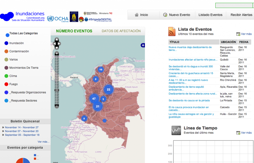
OCHA-Colombia: This activation is specifically for Spanish-speaking volunteers of the SBTF. The purpose is to support the UN’s efforts in mapping the impact of the floods and resulting needs. This information will be shared by other UN partners, various local and international NGOs and a number of government entities. The resulting information will constitute an important input for the decision-making process and for undertaking specific actions to support disaster-affected communities. Note that OCHA-Colombia will be managing this deployment and providing the necessary training.

This double-activation of the SBTF is a first for us, not to mention just days before the holiday period for many of our volunteers. As with other deployments, we’ll do our best to support our humanitarian partners and will take this as an opportunity to learn and improve our workflows. For a list of previous SBTF deployments, please see this link. To join the SBTF, simply follow this link.


Posted in Uncategorized | Tagged , , , , , , , , | Leave a comment

The [unexpected] Impact of the Libya Crisis Map and the Standby Volunteer Task Force

[Guest blog post by Andrej Verity. Andrej is an Information Management Officer at UN-OCHA in Geneva with a focus on both leading OCHA's collaboration with the Volunteer & Technical Communities and supporting OCHA's information management staff around the world. In Andrej deployed to both the Haiti earthquake and the Pakistan floods. In March Andrej lead OCHA's collaboration with the standbytaskforce.com in creating the Libya Crisis Map. Later that month, he also worked closely with Crisis Commons in their data collection exercise in response to the Japan tsunami.]

At the beginning of March OCHA HQ activated the Standby Volunteer Task Force (SBTF), a self-organized group of structured volunteers, to create the Libya Crisis Map (LCM) early in March of this year to help provide better situational awareness of the unfolding situation on-the-ground. This site and the data were made available to responding organizations with the intention to them improve their operational planning. The site was extended beyond the first month largely based on efforts from OCHA Colombia, volunteers sourced from the UNV online volunteer service, and SBTF members who choose to stay on beyond the official SBTF deployment.

But Why the Collaboration?

It comes down to two simple reasons: 1) the UN did not have physical access to the country, and 2) OCHA did not have the idle capacity to gather, verify and process the enormous amount of available online information. In many ways the resulting data behind the map was the “gold mine”. OCHA had a data specialist reviewing the data, looking for patterns or trends in the data, showing what ‘non-map’ products could be generated, and outlining how such data could be integrated into traditional coordination products.

But what measured impact did the map have?

At the moment, a Masters student from Tilburg University is working on a formal impact evaluation of the site. However, measuring the impact of even a traditional static map is not an easy undertaking. What was the measured impact of the last map you used?

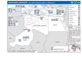
The LCM data was being incorporated into the traditional Who-is-doing-What-Where products and info-graphics which were being created remotely by OCHA IMOs [Colombia, DRC, Ethiopia, Kenya, Pakistan, South Africa, and South Sudan]. These products were then being printed and shared inside the emergency arena. So, what impact did those printed products have? We rarely try to measure their impact on decision makers but recognize they are necessary in every emergency. So, if the LCM data augmented these products, what measurable impact can we say it had?

The challenge in quantifying the impact of information products in situations such as the Libya crisis is they tend to be incomparable to other situations and may yield very skewed outcomes. For OCHA, the impact the volunteers had on the efficiency of the operations and quality of decisions being made is perhaps more interesting. This impact can be more easily quantified by assessing the effectiveness of the decision makers using the maps as input and compared to their workload in other crisis before the SBTF was put into action. This quantifying research is currently being conducted, but on our preliminary qualitative input we can already see that the SBTF has a significant impact on OCHA’s way of working.

The unexpected impact? How we now work differently.

There are three core areas in this collaboration that have influenced OCHA’s work:

1) Speed: as noted in my blog post on UN Dispatch at the end of March, I outlined how much faster we could produce standard IM products in the early phases of an emergency when working with remote volunteers and/or staff. It was quite stark and significant.

2) Connection / Communication: The information management team in OCHA HQ was quite impressed with how well the always-open, tiered Skype chats worked in collaborating with the self-organized task-team based volunteers. The team has taken this approach and opened our own group for OCHA Information Management Officers [which has really made our internal IM Community of Practice flourish and provide support to each other]. We have leveraged the same approach to help incorporate field-based staff into the development of standard tools and software – something we were rather poor at in the past. As well, when we had one IMO responding to floods in Cambodia, we asked for OCHA IM volunteers and placed them in a dedicated Skype group. We ended up with IMOs from Sri Lanka, Pakistan, Cote D’Ivoire, Liberia and Haiti helping out with the efforts.  The OCHA IM team is really learning how we can leverage remote support and are incorporating these concepts into traditional mechanisms.

3) Collaboration Platforms: to collaborate with the external volunteers, we had no choice but to accept the use of non-UN standard software [e.g. Skype and Google Docs]. However, the abilities that these modern tools unlocked helped some of our traditionally skeptical staff members realize there are better ways of working.  It has started a culture change [even if slow].

So, you can easily deduce that OCHA is adopting concepts from the SBTF work style. How much of an impact is that?  Perhaps not quantitatively measurable, but could be qualitatively described a “big”.

But, what challenges arose from the use of new technology and the volunteers?

The challenges can be summarized into three categories:

1. Zoom Level. The volunteers tend to want to work at the highest possible zoom [i.e. close to the affected] and we can understand that desire. However, large responding agencies are dealing with multi-million dollar programme spanning across millions of people in countless locations.  Although they are concerned for the individuals, they need information at a different ‘zoom level’ in order to assess, plan and respond. Thus, we need to ensure that there is a way to aggregate the detailed data appropriately for people or organizations working at different zoom levels.

2. Always On. One major benefit of the volunteers, enabled by modern technology, is that they are dispersed around the world resulting in almost 24 hour support. However, the flip-side of that benefit is that the liaison person from the requesting entity can be faced with questions/issues around the clock if structures, messaging and requirements are not defined early. With the task-team structure used by the volunteers in place, we know that OCHA was sheltered from a large number of questions. Still, in the early days, there were a significant number of topics that arose which needed to be addressed. It meant that we had to be connected all the times - from checking Skype over breakfast, to responding to emails while on the bus, to skipping dinner in the evening to review a risk management strategy.

3. Questions. The volunteers are not necessarily experts – and do not pretend to be when they are not. The challenge for the requesting entity is that someone needs to be available to answer hard questions in a very timely manner. In the Libya context, defining appropriate report categories was one of the first and most challenging questions for OCHA to answer and has reconfirmed that standards are needed.

Did ethical questions arise for the UN?

Of course ethical questions arose during the LCM deployment. They were not specific to the UN. In the Libya context, we dealt with three specific issues:

1. Identify. We did not want any information provided in the LCM that could be used to identify the individual who reported.

2. Location. To avoid anyone from being able to pinpoint anyone reporting, the data was generally anonymized to the centroid of the city it was reported from.

3. Do No Harm. Given the situation in Libya was conflict-based, we needed to ensure that whatever we did minimized the chance of causing anyone harm.

Early in the deployment, OCHA made a decision to run two separate websites. The private site would hold all original data and only be accessible to approved agencies. The public site would show no identifiable information and the data would be delayed by 24 hours. Some have argued that two sites were not necessary [e.g. everything private or only have the anonymized public site], but all we can say is that “It worked”.

What is OCHA doing now?

In June, OCHA held a lessons learned workshop with several of the V&TC entities with whom we collaborated with either for Libya or Japan. That workshop pointed towards 9 thematic Communities of Interest (COIs) to be developed to ensure future collaboration can be maximized [see the final report]. OCHA has been pushing these forward in an attempt to get them started and hosted a one-day meeting with the COI leaders prior to ICCM. [Note: originally a Humanitarian standbytaskforce.com was suggested, but it has morphed to a 'network-of-networks' concept - which will likely be called the Digital Humanitarians - and be designed to receive requests for virtual support and then find the appropriate entities to support those requests]. In the Libya and Japan crisis, OCHA received support from several V&TCs which resulted in some (positive) unexpected impact and we want to continue to explore and understand the possibilities through the COIs mechanism to help maximize the benefit and effectiveness of V&TC engagements with the traditional humanitarian entities.

This collaboration, amongst others recently, has helped to show OCHA’s IM team that we need to open up our work, our data, and our ideas to external parties very much in accordance with the principles Dan Tapscott outlined in Macrowikinomics: Collaboration, Openness, Sharing, Integrity and Interdependence. We are no longer in an era where good ideas only come from inside our own organization, but rather in a time where we have to be open and ready to receive them from outside.

Participants in November COI Leadership meeting included: Crisis Commons, Crisis Mappers, Geeks without Bounds, GISCorp, Harvard Humanitarian Initiative, HOT (OSM), ICT4Peace, Internews, ISCRAM (Tilburg University), MapAction, Missing Persons Community, MIT Humanitarian Response Lab, NetHope, SBTF, UN Foundation, UNHCR, UN-OCHA, UN-SPIDER, University of Munser, UNOSAT, Ushahidi, US State Department (HIU),  Woodrow Wilson Center, World Vision


Posted in Uncategorized | 7 Comments

Who are we really? Stats on the SBTF Membership

The SBTF Membership currently comprises 700+ volunteers from 70+ countries around the world. But who are we really? I finally made some time to find out by reading through every single bio on our Ning platform—a total of 720 when this blog post went to press. Volunteers are invited to write whatever they’d like in their bio’s so these are not structured or standardized. This makes codification somewhat challenging but I was able to pull out some general metrics.

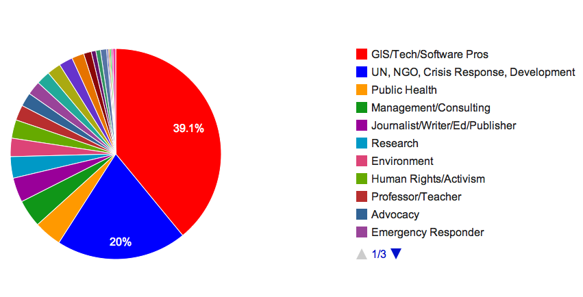
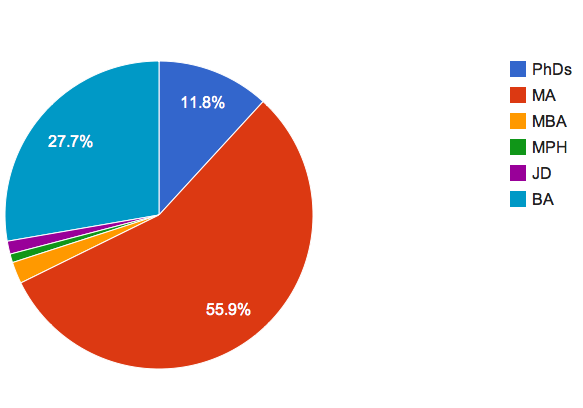
The average age of a Mapster (as we like to call ourselves) is 32.3 years. (Note that about 20% did not include this information in their bio). Also, while many didn’t fill in the gender field, about 65% of volunteers are women. In terms of professions, these are displayed in the pie chart below.

Other professions include economists, lawyers, designers, financial analysts, psychologists, geophysicists and one airline pilot. We also have several retired professionals who are a very important part of this network.

In terms of academic background, many professionals didn’t include this information so the majority of the degrees below are for current or recently graduated students.

I hope to follow up this blog post with a more qualitative one that shares excerpts of bios from volunteers who are happy to have this information made public.

Posted in Uncategorized | Tagged , , | 5 Comments

SBTF Recognized in Online Volunteer Award!

The entire SBTF membership is truly honored and proud to be recognized in this year’s International Online Volunteer Award! The official press release is available online here, which includes this video describing the SBTF’s work on the Libya Crisis Map. Sincere thanks to Andrej Verity for his comments in the video below.


Responding to Crisis Online from UNV on Vimeo.


When we started the year we were just starting to refine our workflows and standard operating procedures. We had fewer than 100 volunteers on the team. With this Online Volunteer Award, we end the year with over 700 volunteers and a lot more experience. We still have some work to do to improve our workflows but we are light years further than when we were just 12 short months ago.

This is a testament to the hard work and considerable time that our absolutely amazing SBTF Coordinators have placed into this unique global volunteer network. A very big thanks to them and every Mapster who volunteered their time during the Libya Crisis Map deployment!


Posted in Uncategorized | Tagged , , , , , | Leave a comment

Beyond Brute Force: Unexpected Lessons from Crowdsourcing Satellite Imagery Analysis for UNHCR in Somalia

The recent SBTF effort to identify IDP shelters in Somalia for the UNHCR has been notable for several reasons beyond the fantastic work by our very, very hard working volunteers; some of whom may now need an eye exam and glasses… And I feel that what I’m seeing is an inflection point in the development of crisis mapping (or indeed any form of “live” or “crowdsourced” mapping). It’s the point at which we move beyond the “brute force” method of chopping large tasks into little pieces and disseminating them among a distributed human network and begin reaping the rewards of the process itself, as a collaborative space for learning and outreach. For me, this has been the most unexpected dimension of this project so far and I wanted to share my thoughts here for feedback. 

I am always skeptical of crowdsourced data or, indeed, any data. As a geographer and remote sensor whose focus is enumerating displaced populations, I have to be: skepticism is part of my job. All data contain error, so best to acknowledge it and decide what that error means. There is still a lot of uncertainty around these types of volunteered geographic information; specifically questions over the positional accuracy, precision, and validity of these data among a wide variety of other issues. These quantitative issues are important because the general assumption is that these data will be operationalized somehow and it is, therefore, imperative that they add value to already confusing situations if this enterprise is to be taken seriously in an operational sense . The good news is that research so far show that these “asserted” data are not – a priori – necessarily any worse than “authoritative” data and can be quite good due to the greater number of individuals to correct error.

It was with this thinking in mind that I joined the current SBTF effort and I very much appreciate the willingness of our great colleagues at Tomnod, DigitalGlobe, JRC, and UNHCR to treat this as an experiment to see how well a very large amount of very specific imagery analysis could be performed with crowdsourcing. We are beginning to analyze the data now and will likely be doing so for the next month or so. What has been surprising, however, have been a few new twists along the way that I feel probably are lost in the exclusively quantitative concerns that so many (myself included) focus on.

  1. There is huge potential here for stakeholder engagement and broadening your outreach: In a time of plummeting budgets, building a constituency for what your organization does is paramount. Efforts such as this give the public and chance to get engaged, to take part in your mission in a fairly easy way. Speaking about the involvement of students from her Air Photo classes at the University of Georgia, Dr. Marguerite Madden said that the engagement, “raised awareness of this grave situation and many [students] got online to find out more information about why this is happening and what is being done to help…” Today there are almost 200 more people who are familiar with the UNHCR and its mission in Somalia than there was two weeks ago. That’s one heck of an ancillary benefit, especially considering that a vast majority of the volunteers are students with the energy and the desire to contribute to a project such as this. Which brings me to the second point…
  2. The collaboration may be as important as the data. I have been consistently (and pleasantly) surprised by the rich discussion among the volunteers about virtually every aspect of this project. We specifically set out to include the academic community and, especially, the remote sensing community by engaging with the student chapters of the American Society for Photogrammetry and Remote Sensing (ASPRS) due to their higher level of familiarity with imagery analysis. Columbia University’s New Media Taskforce and the University of Madison-Wisconsin’s Department of Geography were major contributors and geography departments at both George Mason University and The University of Georgia hosted mapping events (tip of the hat to Lawrence Jefferson and Chris Strother for making those happen). As a result, we created a very rich environment for exchange and learning. Dr. Madden jumped at the chance to use her class as an opportunity to introduce un-orthodox platforms for imagery analysis to her students and everyone benefited. They learned how crowdsourcing for imagery analysis could work in a live environment and we got tons of good feedback on everything from our rule-set to the platform from her very bright students. It’s this meeting of “professional science” and “citizen science” that helps foster new developments in how we approach these emerging practices.
  3. It’s not always about fixes, it’s about concepts: while I believe that Linus’ Law is a powerful argument for crowdsourcing, it’s important to note that this not only applied to technical bugs, but conceptual ones. Part of remote sensing involves creating a rule-set to aggregate features on the surface of the Earth into meaningful classes that allow you to say something about how the world is or works. While there are robust, scientific, ways to go about this it is worth emphasizing the fact that every classification scheme (in any science) is situated within a specific context and point of view. It’s entirely possible to have very well thought out classification schemes that have little to do with the lived reality on the ground. It was with profound humility that I read the very insightful questions posted to our working Google Doc by volunteers, some of whom had zero experience with remote sensing and, yet, had very perceptive insights regarding the assumptions made by our classification scheme. For more than just a steady workforce to place dots on a map, the volunteers really put their thinking caps on to get under the hood of both the technical aspects of the effort but also the conceptual ones. It was precisely their perspective as non-experts that gave them the ability to see things in a new way.

We remain committed to a critical analysis regarding the substantive contribution of our effort to UNHCR operations, but the sense of community in our dedicated channels of communication that allowed for such vibrant discussion should also be understood as valuable. While the operational use of projects like this cannot go unexamined, it bears repeating these types of projects offer much more than just an additional set of data but present a unique forum and opportunity for creative collaboration, engagement, and learning.

By keeping these thoughts in mind we can begin to move beyond the “brute force” period in crisis mapping, in which complex and – generally – machine-driven functions are simply distributed to a human network and, instead, expand the meaning of geographic data in these new spaces of engagement.

Many thanks to all who have participated in the project thus far. As always, you are fantastic teachers.

Posted in Uncategorized | Tagged , , , , , , | 2 Comments